Oil and Gas Field Maps & Info
Use these links to find static maps of oil and gas fields and
associated statistics
Oil
and Gas Statistics: Bureau of Land Management. Below are links to tables and spreadsheets with data that include the numbers of BLM-administered oil and gas leases, applications for permit to drill, and oil and gas wells. .
Detailed
Oil/Gas/Coalbed Methane Field Maps: United States Energy Information
Administration. Basin-specific oil and gas field maps are included
and show the locations, boundaries, names, and either the barrel-of-oil
equivalent (BOE), the liquid hydrocarbon (crude oil plus lease
condensate), or the natural gas reserve size for each field (2001
data). Additional maps include the 100 volumetrically largest
oil and/or natural gas fields for proved resources and the status
of coalbed methane in the United States. Maps are in PDF format.
Oil
and Gas Fields and Pipelines of Utah: Large map showing
oil and gas fields, reservoir rock types, oil and gas pipelines,
and operators. Map is in PDF format. Web site contains additional
geologic maps.
Interactive Web Mapping
Use these links to explore interactive maps and create your own
purpose-built maps. Interactive maps allow users to search and
explore available data, which can then be dynamically mapped and
exported.
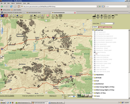
National Integrated
Land System Geocommunicator: GeoCommunicator provides searching,
accessing and dynamic mapping of BLM activities including Oil,
Gas, and Geothermal Leasing, Coal and Other Solid Mineral Leasing,
Right-of-way (ROW) Corridors, Stipulations (no surface occupancy etc.),
Mining Claims (unpatented), Land Use Permit, Land & Mineral
Title, and many more.
United States Energy Information Administration, U.S. States: Provides State profiles and energy estimates for the United States and U.S. territories. Provides current statistics for Economy, Prices, Reserves & Supply, Distribution & Marketing, Consumption, and Environment. The EIA mapping tool allows users to view the location of individual oil and gas wells across the country by checking "oil and gas wells" in the mapping system's "Layers/Legend" drop-down menu.
USGS
National Oil and Gas Assessment: Interactive map showing oil
and gas basins of the US with links to full geologic reports and
individual assessments for each basin with information on discovered
and undiscovered oil and gas resources.
Colorado
Oil and Gas Conservation Commission Interactive Maps: Provides
searching accessing, and dynamic mapping of Colorado oil and gas
leases, wells, pits, stipulations, water wells, groundwater, well
samples, land ownership, methane seeps, soils, etc. Includes an
additional interactive map for wildlife habitat. (Mapguide
6.5 plug-in required)
Colorado
Division of Water Resources-Decision Support System:
Interactive map tool for making water resource decisions. Includes
stream gauge data, water diversions, climate data (evaporation,
precipitation, radiation), instream flow, hydrography, land use,
groundwater levels, and groundwater wells.
Utah
Oil and Gas Well Locator: Interactive map tool for locating
oil and gas wells in Utah. Shows oil and gas fields, wells, and
associated data.
Montana
Board of Oil and Gas Conservation Webmapper: The WebMapper
was developed to provide the citizens of Montana, the oil and
gas industry, and other interested persons the ability to visually
examine the spatial location of oil and gas producing wells throughout
the state as related to roads, townships, rivers, and other cultural
features.
Wyoming
Oil and Gas Conservation Commission Map Server: Interactive
mapping for Wyoming
New
Mexico State Land Office-Geographic Information Center
LOGIC (Land Office Geographic Information Center) provides a web
map-viewer for general land status and oil/gas/minerals. The map
viewer allows users to search and view by township, range, lease
number, and well API number.
SAGEMAP
Interactive Map: Sagebrush And Grassland Ecosystem Map Assessment
Project. SAGEMAP provides spatial data for the management of shrubsteppe
and associated wildlife (sage grouse) in the western U.S. SAGEMAP
is in the process of creating an improved interactive map, but
the old one is still available for use.
Images from:
http://legacy.panola.edu/instruction/gis/
http://www.imagin.org/about_imagin
http://www.geocommunicator.gov/
Other Resources
Areas of Historical Oil and Gas Exploration and Production in the United States, USGS: This report contains maps and associated spatial data showing historical oil and gas exploration and production in the United States. A hardcopy map was created to synthesize recorded exploration data from 1859 to 2005. In addition to the hardcopy map product, the data have been refined and made more accessible through the use of Geographic Information System (GIS) tools.
GIS for Petroleum, ESRI: Provides information on how GIS is used in all stages of the oil and gas development process, including success stories.
GIS Best Practices for Renewable Energy, ESRI (pdf): A 2010 ESRI paper discussing how GIS can help develop best practices for renewable energy.
SKYTRUTH:
SKYTRUTH is a non-profit organization specializing in aerial photography
of environmentally impacted sites. Includes a variety of galleries
of sites impacted by gas and oil development.
|
Downloadable GIS Data
Use these links to find, access, and download spatial data for
use in a geographic information system. Most data are in shapefile
format for use in GIS software, such as ArcGIS.
Bureau of Land Management GIS Data:
Includes statewide oil and gas data as well as land use designations (data availability varies by state).
Colorado, Montana, New Mexico, Utah, and Wyoming
Colorado
Oil and Gas Conservation Commission GIS: Includes
shapefiles for wells, facilities, permit locations, wildlife habitat,
Roan Rim buffer, etc. [Go to Maps --> GIS Downloads]
Montana Geographic Information Clearinghouse: A comprehensive collection of geospatial data for Montana.
Natural
Diversity Information Source: Colorado Division of Wildlife.
Includes shapefiles of statewide wildlife species activity, vegetation,
hydrography, and administrative boundaries.
New Mexico Resource Geographic Information System Program: A GIS data clearinghouse for New Mexico, including land use/ownership, geologic, and boundary data.
SAGEMAP, USGS:
Includes thousands of data files related to shrubsteppe management
and wildlife including sage grouse.
 Utah AGRC (Automated Geographic Reference Center): The State Geographic
Information Database (SGID) contains files and links to many different
categories of data sets including environment, geology, energy,
wildlife, hydrology, land cover, and cultural. Utah AGRC (Automated Geographic Reference Center): The State Geographic
Information Database (SGID) contains files and links to many different
categories of data sets including environment, geology, energy,
wildlife, hydrology, land cover, and cultural.
Utah
Division of Wildlife Resources GIS Data: Available data include
threatened, endangered, and sensitive species occurrences, bird
and mammal habitat coverages, hunt boundaries, and management
units. Data are in shapefile format.
WyGISC Data Services: Provides several resources to access and download GIS and other geospatial data: the Wyoming GeoLibrary, central location for discovery of and access to geospatial data for Wyoming. Download imagery and Topos from the WyGISC Imagery Server. Clip and zip available through the WyGISC Data Server.
Wyoming
Landscape Conservation Initiative (WLCI) -Data Clearinghouse: Thiis data clearinghouse is an effort to catalog and provide access to all of the available data and information resources important to the WLCI: a long-term science based effort to assess and enhance aquatic and terrestrial habitats at a landscape scale in southwest Wyoming, while facilitating responsible development through local collaboration and partnerships.
Free/Open Source GIS Software
These free GIS applications allow users to view data layers and
perform simple analysis.
ArcGIS Explorer and Desktop, ESRI: A free GIS viewer that provides an easy way to explore, visualize, and share GIS information.
ArcReader
ArcReader is a free, easy-to-use desktop mapping application that
allows users to view, explore, and print maps and globes. Anyone
with ArcReader can view high-quality interactive maps authored
by a higher level ArcGIS Desktop product and published with the
ArcGIS Publisher extension. ArcGIS is the preferred GIS software
used by over 80% of all GIS professionals.
GRASS
(Geographic Resources Analysis Support System)
GRASS is used for geospatial data management and analysis, image
processing, graphics/maps production, spatial modeling, and visualization.
Quantum
GIS
Quantum GIS (QGIS) is a user-friendly open source GIS that runs
on GNU/Linux, Unix, Mac OSX, and MS Windows. QGIS supports vector,
raster, and database formats and is licensed under the GNU General
Public License.
SPRING
A state-of-the-art GIS and remote sensing image processing system with an object-oriented data model which provides for the integration of raster and vector data representations in a single environment. SPRING is a product of Brazil's National Institute for Space Research.
|
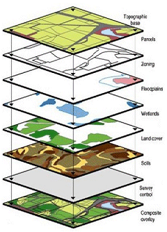
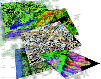 Geographic
Information Systems (GIS) are powerful computer-based tools used to
enter, maintain, store, distribute, and analyze geospatial data. GIS
and associated spatial analyses deal with the quantitative location
of features and their associated attributes. GIS have been implemented
across a broad range of research, science, business, and government
applications. GIS are particularly effective for managing natural resources.
As the development of oil and gas resources expands in the Intermountain
West, so does the need for spatial data and spatial awareness of development
impacts. GIS can be utilized to document and examine the potential and
observed effects of oil and gas development on all impacted resources
including: water, wildlife, cultural/historic, habitat, air quality,
socioeconomic, vegetation etc. Furthermore, GIS provides a tool for
oil and gas operators to effectively and efficiently manage development
for the protection of resources and optimal production.
Geographic
Information Systems (GIS) are powerful computer-based tools used to
enter, maintain, store, distribute, and analyze geospatial data. GIS
and associated spatial analyses deal with the quantitative location
of features and their associated attributes. GIS have been implemented
across a broad range of research, science, business, and government
applications. GIS are particularly effective for managing natural resources.
As the development of oil and gas resources expands in the Intermountain
West, so does the need for spatial data and spatial awareness of development
impacts. GIS can be utilized to document and examine the potential and
observed effects of oil and gas development on all impacted resources
including: water, wildlife, cultural/historic, habitat, air quality,
socioeconomic, vegetation etc. Furthermore, GIS provides a tool for
oil and gas operators to effectively and efficiently manage development
for the protection of resources and optimal production.